


Mouse Over any image for a larger view...to see more pictures from the trip click here
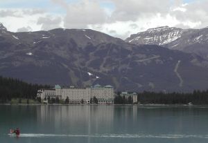 The planning for this trip evolved from an interest to try biking a week on our tandem. We had previously made a one week’s bike tour through Switzerland with a commercial tour company (Rotalis) but found their equipment (upright 7 speeds) less satisfying than our Santana. The decision to ride the Canadian Rockies was predetermined by a meeting that Becky had scheduled at the Chateau on Lake Louise for the last weekend in June. We first considered using a commercial tour company, but after reviewing several web sites, I had a good idea of the route and available facilities and realized that we could manage the trip self contained for less than half of the cost of the commercial operators. The only challenge that I couldn’t resolve was the logistics of returning the bike to Lake Louise where the car was parked; there probably is a service, but I couldn’t find it so we decided to make a round trip from the Fairmont Chateau to the Columbia Icefields and back. I joined Becky at the conclusion of her meeting on Sunday June 26 after driving 2400 miles from Houston to Lake Louise in 3 days. Our bike is a one-piece Santana Noventa which I packed into a BikePro soft sided case and slid into the back of my VW Jetta wagon. After arriving at Lake Louise, the staff valets moved the bike into the ski storage area where I reassembled it from the packing case.
Monday 27 June 2005
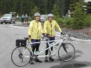 We are ready for our first ride. We planned to ride the Bow Valley Parkway in the direction of Canmore and return after a comfortable distance. We thought this would be a good chance to experience the high altitude atmosphere on a relatively level road. The parkway essentially follows the route and gradient of the Bow River. As fate would have it, Canada was experiencing the wettest June in 200 years. The skies were overcast, temperature at 52 degrees and a slight drizzle. We were advised that the weather may not get any worse, but not to expect a lot of improvement. The biggest problem with departing the Chateau on Lake Louise in the rain is a 2 mile long 9% grade descent with curves and traffic. Using maximum drag brake with occasional caliper brakes we managed the hill and found the parkway. This is a biker friendly road with little traffic as most of the traffic is on the CanPac highway 1 across the river. There are no shoulders but plenty of turnouts. It’s mostly a forested ride but the mountain vistas are easily visible above the trees. The drizzle stopped about 30 minutes into the ride and the road surface began to dry out. We stopped at the Castle Mountain Junction for a cup of hot cocoa and a cookie; we were 20 miles from the Chateau and decided this would be a good place to return. We were concerned about the trip back because it seemed that the ride out was mostly downhill (we had a 17.3 mph average at the break); but the return was only a little more difficult except for the final 2 mile uphill to the Chateau. We did manage to pull it but with one stop to catch some air. As we arrived in the parking lot, the valet came out to the bike, gave me a claim ticket and returned the bike to storage…first time for me to have my bike valet parked. Total miles 40. Average 16.4 mph. Elevation climb 640 feet.
Tuesday 28 June 2005
We awoke to a drizzling rain and heavy overcast with an outside temperature hovering at 50 degrees. We had learned from the previous day that the rain tends to quit in the late morning and because we had a fairly short distance to ride we decided to wait until 11:30 (or sooner if the rain stopped) before leaving for the Bow Pass. By 11:30 the rain had stopped but the roads were still wet; however the weather was as good as we would see for the 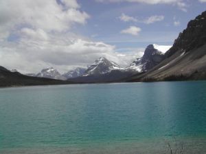 rest of the day. We gave the valet our claim check and he brought the bike to the front of the Chateau where we attached the panniers and trunk and started the ride to the Num Ti Jah lodge on the Bow Lake. The distance was only 28 miles but the elevation climb was 2900 feet. This was my first experience of a total up hill ride without any significant downhill to rest. The route took us on the shoulder of the CanPac highway for 4 miles before turning onto highway 93, the Icefields Parkway. This is a two lane highway with a comfortably wide shoulder. The shoulder surface was generally good with only minor cracks and gravel debris. There is traffic…lots of RV’s, tour busses, motorcycles and SUV’s. Some respect the bicycles on the shoulder…others don’t yield an inch. There are turnouts at interesting vistas, some even have toilets. We kept the camera in the captains back jersey pocket so the stoker could grab pictures as we rode…this was only marginally successful…it’s probably advisable to stop and take
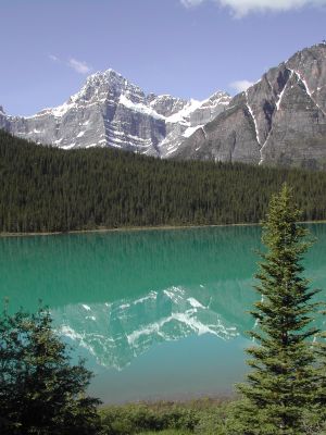
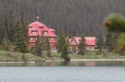 a picture if you want a good result. We managed the 28 miles in just under three hours including stops to view Hector Lake and the Crowfoot Glacier. As we crested the last climb, the sight of Bow Lake with the Num Ti Jah lodge on the shore was a true reward for the effort it took to get there. The lodge is an experience in itself…visit their website for a detailed description. There wasn’t a valet waiting for us, but they allowed us to bring the bike into the lobby for the night. There were some other bikers in the lodge that night who were on a Backroads tour. We visited with the tour leaders who provided some useful information about the remainder of the trip. (We used booties over our shoes…that is essential equipment for riding in the rain) Total miles 28. Average 9.8 mph Elevation Climb 2900 feet.
Wednesday 29 June 2005
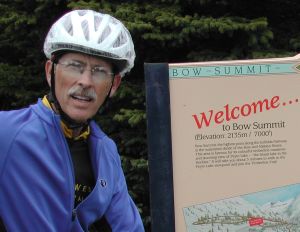
 We awoke to clear skies and 55 degrees; best weather of the trip. We had planned for this to be our most challenging day so needed to get an early start. After breakfast we loaded the panniers and started the final 2 mile climb to the Bow Pass elevation 6700 feet. From there it was downhill all the way to the Saskatchewan Crossing, a 3000 foot descent in 28 miles. This was the halfway point from Bow Lake to the Columbia Icefields. We had planned reservations for the night there so we could drop the panniers and lighten the bike by 25 pounds before continuing the 23 mile climb to the Sunwapta Pass. The last 5 miles up to the pass is an 8% grade. There is a double climbing lane but no shoulder for the incline so we took the middle of the slow lane. We did have to stop frequently to get breathing regulated, but managed the ascent in about 45 minutes; we achieved our goal to arrive at the Icefields Chalet before 3:00 for lunch and rest. The ride back down to the Saskatchewan Crossing was the most thrilling ride we have ever made. I used the drag brake when approaching the turns but when traffic and road conditions permitted we tucked and let the bike run free. We achieved a maximum speed of 50 mph; the wind is a little squirrelly at that speed and goggles would have aided vision, but that was an experience which has set the standard for excitement. The remainder of the ride back to the Crossing was about 50% coasting and 50% pedaling; we did stop a couple of times to see the sights that we had passed on the way up. We arrived back at the Crossing a little before 6:00, checked into our room and visited the on premises pub to celebrate the ride and enjoy dinner. One interesting note about this pub…there is no cook in the kitchen.
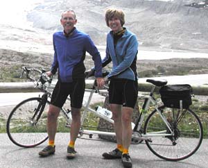 When you order your meal, the waitress brings a piece of raw meat and shows you to the grill…from there on it’s your job to cook to your specifications. Total miles 90 Average 12.8 mph. Maximum speed 50 mph. Elevation Climb 3400 feet Elevation down 6400 feet.
Thursday 30 June 2005
 climb to 7000 feet. All the literature indicated that the side trip was worth the effort and I have to agree with them. As we reached the parking area for Peyto Lake, a man approached us and asked if we were hungry…well, it was about noon and yes we were hungry. He was the tour leader for Bike Adventures and we had stumbled into their lunch break. We accepted their invitation and enjoyed the sandwich and salad. There was a tandem team in their group from Fort Worth who are members of the DATES. When they saw our SWTR jerseys we had an immediate bond. We only regret that we didn’t have more time to visit and exchange biking stories. The group from Bike Adventures was headed to the Sunwapta Falls for the night so they had another 4 hours of riding to go. We were about 4 miles from the Num Ti Jah lodge and that was all downhill. The rain continued for the remainder of the afternoon…we passed the time in the library playing games and rehydrating with beverages of choice. Total miles 28: Elevation climb 3200 feet: Average
9.8 mph.
climb to 7000 feet. All the literature indicated that the side trip was worth the effort and I have to agree with them. As we reached the parking area for Peyto Lake, a man approached us and asked if we were hungry…well, it was about noon and yes we were hungry. He was the tour leader for Bike Adventures and we had stumbled into their lunch break. We accepted their invitation and enjoyed the sandwich and salad. There was a tandem team in their group from Fort Worth who are members of the DATES. When they saw our SWTR jerseys we had an immediate bond. We only regret that we didn’t have more time to visit and exchange biking stories. The group from Bike Adventures was headed to the Sunwapta Falls for the night so they had another 4 hours of riding to go. We were about 4 miles from the Num Ti Jah lodge and that was all downhill. The rain continued for the remainder of the afternoon…we passed the time in the library playing games and rehydrating with beverages of choice. Total miles 28: Elevation climb 3200 feet: Average
9.8 mph.
Friday 01 July 2005
This was the final day of the tour; only 30 miles, mostly downhill from Num Ti Jah to the Chateau on Lake Louise. The day was overcast with an intermittent drizzle; temperature in the low 50’s. We did stop at a few locations to take pictures of the landscape but generally we were cruising for Lake Louise like a horse headed for the barn. The carrot was lunch and libations at the Grizzly Paw Brew Pub in Canmore. The 2 mile, 9% pull up to the Chateau with panniers was challenging, but the reward was waiting in Canmore. The valets met us at the entrance; we took the panniers and slapped a couple of high fives to signify the conclusion of a wonderful ride through the Canadian Rockies. Total miles 30: Elevation Down 2900 feet: Average 16.6 mph.